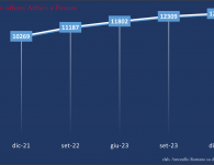
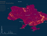
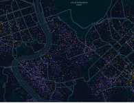
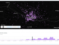
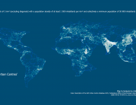
La mappa mostra la localizzazione circa delle Cell Tower sulla base dei dati collezionati attraverso il servizio OpenCellID, un progetto collaborativo che raccoglie le posizioni GPS delle/dalle Cell Tower.
N.B. Metodologia:
“A measurement in the OpenCellID context is a GPS position where the radio signal of a GSM base station has been received. If measurements of the same base station have been received at different places, then the average of all GPS latitude values and the average of all GPS longitude values is calculated and this average GPS position is then stored in the OpenCellID cells database. This average position is then also shown on the OpenCellID map. In case there is only 1 measurement for on GSM base station, this position is indicated to be the position of the cell tower at the same time, which is not necessarily true. The only way to improve the precision of the shown position of a GSM base station is to provide OpenCellID with as many as possible measurements with different GPS positions”.
 OpenCelliD Project is licensed under a Creative Commons Attribution-ShareAlike 4.0 International License